Peak 8 - 12,987 feet
Peak 7 - 12,665 feet
from Grand Lodge on Peak 7 (top of Ski Hill Road)
"Trailhead":
Park at the ‘Peaks Trailhead’ just past the ‘Grand Lodge’ on Ski Hill Road. Walk back on Ski Hill Road toward the Gondola, and then climb a staircase to reach the gap between the “Crystal Peak Lodge” and “Grand Lodge”. You should walk past Sevens Restaurant and have a clear view of the Independence Superchair.
 Special Note
 Please do not mess with any of the equipment or signage inside the ski area. Respect Breckenridge Ski Area’s property. I did talk to a representative from Breck and they told me that you are allowed to hike around on their ski runs in the non-skiing seasons.
From here, you goal is to climb 1,400’ of elevation by any route you desire. The most direct way is to take the Pioneer run which Parallels the lift for most of the time. Another good way to go that adds a fraction more distance is to hug the Northern border of the ski area by taking Monte Cristo or Angels Rest. It’s a nice route. You may find small climber’s trails or Mountain Bike Trails near the edge of the runs weaving in and out of the trees. As long as you are following a Breckenridge ski run, you will reach the top of the
Independence Superchair. Once the top of the ski lift is reached, hike West through a small patch of trees and break into an open meadow with a view of much of the remaining route. There is a very rocky gulch to your right, where the start of the ridge also lies.
 |
| Looking South-East from just above the Independence Superchair |
 |
| Looking ahead from the same area |
Here you have two options. Option 1 is probably the best, which is to head over to the ridge and climb that to the summit. Option 2 is recommended in high wind conditions- climb the East slopes. Let me start out by offering a word of
caution. This area is blasted heavily in the winter for Avalanche mitigation. Keep this in mind, watch where you place your feet. There could be unexploded ordinance about, and that would be dangerous to mess with. I saw lots of avalanche blasting debris, but no UXO.
 |
| Looking down about 100' from the summit. You can see the independence superchair and the Grand Lodge near the middle |
 |
| Looking up toward the summit |
 |
| Peak 8 from below Peak 7 |
Regardless of the route you choose, there will be little challenge for you to ascend to the summit of Peak 7; Class 2 climbing at best. The summit is odd in that the actual highpoint isn’t easily determined, there are a trio of slightly prominent mounds on top. It's about 1600 vertical feet from the Independence Superchair to the summit of Peak 7.
 |
| Breck from the summit of Peak 7 |
 |
| Peak 8 from Peak 7. It's actually a little closer than it looks |
 |
| Lake Dillon from P7 summit |
From the summit of Peak 7 (unranked), it’s only 45’ down a very gentle slope to the saddle. The trek up Peak 8 is pretty simple, only getting somewhat steep near the top of the 400’ climb. There are some faint climber's trails near the top. The views from the summit of Peak 8 are pretty great. You can see quite a lot of interesting things from the summit including Grays and Torreys, Holy Cross, Copper Mountain, Buffalo Mountain and the southern Gores, etc.
 |
| Looking South, Peak 8, Peak 10, and Crystal Peak should be all here somewhere |
 |
| Looking down toward Breck from 12,978' summit of Peak 8. You can see the Imperial lift not far below the summit. |
 |
| Upper Breck ski terrain |
 |
| Looking down toward the Climax Mine area |
From the summit I went down to the Imperial Lift, and then followed that ridge down until I hit the Summit Haus.
 |
| Looking to Lake Dillon from the Imperial Express sign |
 |
| Impressive |
 |
| I really want to try this run in a couple months on my snowboard, if I can manage to make it to the base of the Imperial Express Lift without freezing |
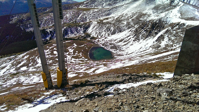 |
| Lake seen below the lift. In the winter, this freezes over and is covered with snow, and people ski right over it unawares. |
From here I hooked up with some dirt roads for an easy slightly downhill jog, and then cut down wirepatch back to the Grand Lodge. Coming down was very straightforward, and it’s easy to see landmarks to orient yourself.
Times: Lodge to Peak 7: 1 hour, 30 minutes
Peak 7 to Peak 8: 20 minutes
Peak 8 to Lodge: 44 minutes ( I did some light jogging)
Total Elevation gain: ~3,100’
Total Distance: Estimated 5-6 miles
Personal thoughts:
This is a pretty decent hike, although the lack of a defined trail could be a danger to some. Class 2 is the maximum difficulty you should encounter, and the abundance of man-made landmarks make navigation pretty simple. In addition to this, I had cell phone service over 90% of the time, including on the summits, so a cell phone would be worth bringing along. (I have AT&T) Compared to other summit hikes, the area is not as pristine as the surrounding area. There is more trash, pickets, fences, ropes, and blasting debris. Still, there are some good views to be had from the summit, and if you are a fan of Breck this is a nice alternative view of the ski runs and of the city. I enjoyed my hike quite a bit. If you make it to Peak 7 summit, Peak 8 summit is close at hand and offers a much better view of the surrounding area.
On a side note, it was very windy and rather chilly. On the summit ridge I was experiencing 30+ mph sustained winds that chilled me to the bone. It was so windy I had a hard time taking pics on the Peak 8 summit. Once I descended about 500', the weather became very pleasant.


